
|
||||||||||||||||||||||||||||||||||||||||||
|
| ||||||||||||||||||||||||||||||||||||||||||
 |
 |
 |
 |
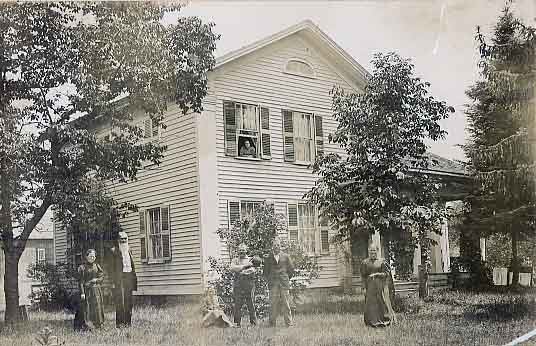
 Wright’s Corners Had the Right Stuff for Settlement  In the very early years of the 19th century, when Niagara County was still part of Genesee County, those few people who ventured west toward Niagara Falls traveled on the Indian path along the Ridge (now Rt. 104). The high ground, though bumpy and tree-ladened, provided the best route through the forests of this area. The road was generally dry until one reached what is now present day Wright’s Corners. This stretch, between Wright’s and Warren’s Corners, was once part of the ancient Lockport-Newfane Bay and Delta. The high ridge was interrupted for a few miles, giving way to swamps and springs, until you reached Warrens’ and the resumption of the ridge. In 1832 when British traveler and diarist Fanny Trollope arrived at what was then called Wrightsville she wrote, “when this ridge ceased, the road ceased too, and for the rest of the way to Lockport, we were most painfully jumbled and jolted over logs and through bogs, till every joint was nearly dislocated.” During the War of 1812, the U.S. military built a log or corduroy road through this section to accommodate infantry going back and forth from Fort Niagara. At this time a man named Thomas Barber arrived at the present intersection and built a log tavern on the southwest corner of the Ridge Road and the Lockport-Olcott Road. He saw an opportunity for weary soldiers and later settlers to rest there before continuing their journey either east or west. Five years later another log tavern opened directly across the road from Barbers’. This one was operated by Alva Buck. Barber died in 1818 and his wife continued the business until 1820 when the tavern caught fire killing two of their daughters. In 1822 Solomon Wright leased the Buck tavern and purchased it in 1830. After extensive expansion and remodeling, he ran the hotel for the next 31 years until it too burned in 1861. Solomon Wright died in 1872. In the 1820s and 1830s the hamlet was called “Wrightsville.” The northern half was situated in the Town of Newfane and the southern half in the Town of Lockport. In fact Solomon Wright’s house was on the Lockport side while his hotel was on the Newfane side. In 1826 Wright petitioned the U.S. government to establish a Post Office, offering his home as the location. In 1839, the government, for some unknown reason, changed the name of the hamlet to Wright’s Corners. Wright remained Postmaster for 45 years. There were other reasons that the hamlet became attractive to many early settlers. In those early days, Newfane was a “dry” town where alcohol was not sold. Lockport, on the other hand, was a “wet” town (how could it be otherwise with the canal running through it). Wright’s Corners prospered with the addition of taverns, stores, schools and a Presbyterian Church. Though it never achieved the fame of Lockport to the south or the popularity of Olcott to the north, Wright’s Corners became a crossroads of sorts for travelers from all directions. The largest landowner, and most prominent citizen after Solomon Wright, was Col. John Henning. A veteran of the War of 1812, Henning purchased a 270 acre farm on both sides of the Ridge Road, heading east, in 1835. He was known as the “unofficial mayor” of Wright’s Corners. The family donated the land for the Presbyterian Church in 1872. Col. Henning passed away in 1870 and his sister Janette died in 1877. The property was inherited by a nephew, John Henning II, who resided there with his family until his own death in 1893. At some point prior to 1860, a road was cut through the Henning property. Originally named Henning Road, it is now the Wheeler Road. Much of the original Henning property is now occupied by the Tops plaza and McDonalds. With the coming of the canal, the railroad and later automobiles, Wright’s Corners lost its place as a resting point for weary stagecoach travelers, although cars now stop to fill up at the local gas station that stands where Thomas Barber first built his log tavern almost two hundred years ago. Photo Caption: The Col. Henning House, built 1835, formerly located at the corner of Lockport-Olcott Road and Wheeler Road. Torn down to build Tops Markets. Douglas Farley, Director Ann Marie Linnabery Erie Canal Discover Center 24 Church St. Lockport NY 14094 716.439.0431 CanalDiscovery@aol.com www.NiagaraHistory.org |
|